How to get from Central to Lantau Peak (Pak Kung Au)
Updated
Lantau Peak is Hong Kong's second-highest mountain. The usual route starts at Pak Kung Au and ends at Ngong Ping and the Big Buddha. Take the Tung Chung Line to Tung Chung (Exit D, Fu Tung Street), walk to the Fu Tung Plaza bus stop and take bus 3M or 11 to Pak Kung Au.
Best season: October to March. Pak Kung Au to Ngong Ping is about 3 to 4 hours, and very steep.
The short answer
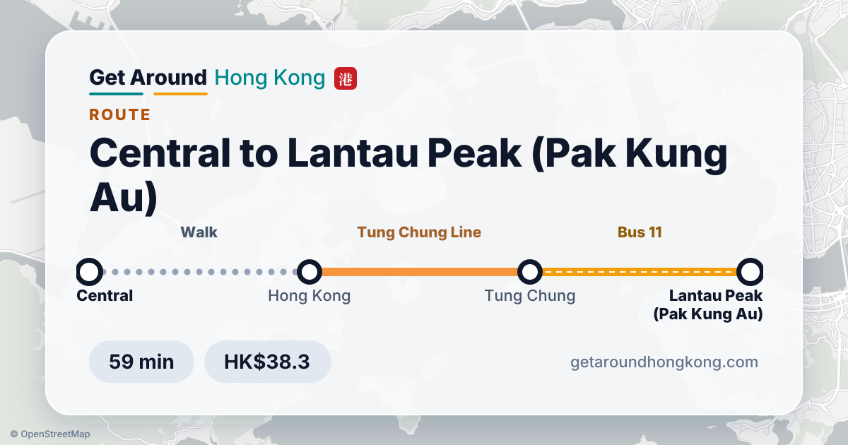
- Fastest: Tung Chung Line → Bus 11 · 59 min · HK$38.3
- Cheapest: Bus E11 → Bus 3M · 105 min · HK$28.8
Route map
Ways to get there
Planned for a weekday at 10 am with today's timetables. Fares are Octopus fares in HK dollars.
59 min · 1 change
FastestTung Chung LineBus 11
- Walk 7 min to Hong Kong · go in at Exit C (Douglas Street)
- Tung Chung Line (towards Tung Chung): Hong Kong → Tung Chung · 7 stops · 33 min
- Exit D (Fu Tung Street) · Walk 4 min to Fu Tung Plaza, Tat Tung Road
- Bus 11 (towards Tai O): Fu Tung Plaza, Tat Tung Road → Pak Kung Au · 11 stops · 13 min
- Walk 2 min to Lantau Peak (Pak Kung Au)
Adult HK$38.3 · Child HK$19.5 · Senior HK$7.7
105 min · 1 change
CheapestBus E11Bus 3M
- Walk 2 min to Pedder Street
- Bus E11 (towards Skycity): Pedder Street → Tung Chung Fire Station, Shun Tung Road · 7 stops · 76 min
- Walk 3 min to Yu Tung Court, Shun Tung Road
- Bus 3M (towards Mui Wo Ferry Pier): Yu Tung Court, Shun Tung Road → Pak Kung Au · 10 stops · 15 min
- Walk 2 min to Lantau Peak (Pak Kung Au)
Adult HK$28.8 · Child HK$14.5 · Senior HK$6.3
Step-free route
For wheelchairs, prams and heavy luggage: lifts and level access only, with no minibuses or trams.
72 min · 2 changes
Airport ExpressBus S1Bus 11
- Walk 11 min to Hong Kong · go in at Exit A (Two International Finance Centre)
- Airport Express (towards AsiaWorld-Expo): Hong Kong → Airport · 3 stops · 21 min
- Walk 7 min to Terminal 1 (North), Cheong Tat Road
- Bus S1 (towards Tung Chung Station): Terminal 1 (North), Cheong Tat Road → Tung Chung Station · 7 stops · 13 min
- Walk 3 min to Non-Franchised Bus Loading And Unloading Area Of Tung Chung Station Bus Terminus, Tat Tung Road
- Bus 11 (towards Tai O): Non-Franchised Bus Loading And Unloading Area Of Tung Chung Station Bus Terminus, Tat Tung Road → Pak Kung Au · 12 stops · 13 min
- Walk 3 min to Lantau Peak (Pak Kung Au)
Adult HK$137.7 · Child HK$68.9 · Senior HK$64.8
Good to know
- Bus 3M is usually the cheaper of the two. The trail starts across the road from the Pak Kung Au stop.
- Coming back, walk down to Ngong Ping and take bus 23 to Tung Chung MTR. Check the live departures before you start down: the last bus can be earlier than you expect.
- It's a hard climb with steep stone steps and no shade. Allow plenty of daylight.
- Sunrise hikes are popular, but buses to Pak Kung Au don't run before dawn, so check the first bus.
- Step-free: the trail is not accessible. Ngong Ping village and the cable car are.
- More: Tsim Sha Tsui to Ngong Ping, Central to Dragon's Back, Central to Lamma Island.
Things to do there · Ad


Questions
How do I get from Central to Lantau Peak (Pak Kung Au)?
The quickest way is Tung Chung Line → Bus 11, about 59 minutes and HK$38.3 for an adult with Octopus. The cheapest is Bus E11 → Bus 3M at HK$28.8, about 105 minutes.
How long does it take from Central to Lantau Peak (Pak Kung Au)?
About 59 to 105 minutes on a weekday morning, depending on which way you go.
How much does it cost from Central to Lantau Peak (Pak Kung Au)?
From HK$28.8 for an adult paying by Octopus. On the same route children pay HK$14.5 and seniors HK$6.3.
Is there a step-free route from Central to Lantau Peak (Pak Kung Au)?
Yes: Airport Express → Bus S1 → Bus 11, about 72 minutes, using lifts and level access all the way.
How do I get to the Lantau Peak trailhead?
MTR to Tung Chung (Exit D), then bus 3M or 11 from Fu Tung Plaza to Pak Kung Au.
What's the last bus back from Ngong Ping?
Bus 23 runs to Tung Chung. Check the live departures on this page, and the NLB timetable, before you start down.
How long does it take?
About 3 to 4 hours from Pak Kung Au to Ngong Ping.
How this guide is made
Routes, journey times and fares on this page are planned every day from the Transport Department's and the MTR's official open data on DATA.GOV.HK, and were last updated on 26 October 2026. Live departure times in the planner come from the operators' own feeds. The tips are our own.
- Headway information of public transport services (Transport Department)
- MTR routes, fares and barrier-free facilities (MTR Corporation)
- Real-time arrival data from bus, minibus, MTR and ferry operators (DATA.GOV.HK)
- OpenStreetMap (OpenStreetMap contributors)
More route guides
- Arriving at the airportHong Kong Airport → Central
- Islands, hikes and quiet spotsCentral → Dragon's Back
- Islands, hikes and quiet spotsCentral → Lion Rock (Sha Tin Pass)
- Islands, hikes and quiet spotsTsim Sha Tsui → Sai Wan Pavilion
- Islands, hikes and quiet spotsCentral → Lamma Island
- Islands, hikes and quiet spotsCentral → Cheung Chau